BAE
BAE Meets Royal Air Force Deadline and Stringent Requirement for Safety and Security
VxWorks RTOS and development tools power the radar map display system of advanced fighter jets

“By standardizing on the Wind River platform for the TARDIS project, we have a software foundation that can allow us to accelerate the development of the design and meet the stringent requirements for safety and security.”
—BAE
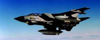
THE OBJECTIVE
The Royal Air Force needed to quickly develop error-free navigation for its Tornado GR4 low-level attack jet. The system—known as TARDIS—requires on-the-fly processing of radar data and digital moving-map display data for both pilot and navigator. The challenge was to reliably integrate multiple highly sophisticated software applications to produce full-color, real-time displays.
HOW WIND RIVER HELPED
BAE chose the VxWorks® real-time operating system (RTOS), its development tools platform, and Wind River® Professional Services to deliver a state-of-the-art Tornado Advanced Radar/Map Display Information System, aka TARDIS.
THE RESULTS
Using Wind River products and services, BAE avionics engineers were able to meet their challenging deadline with a state-of-the-art system that uses liquid-crystal active matrix displays, the latest radar processing techniques, and map-generation software and graphics. TARDIS provides digital color display screens for the pilot and navigator, who can view displays together or independently. The system integrates radar data and digital moving-map display data to provide optimal situational awareness for low-level terrain navigation and avoidance capabilities.